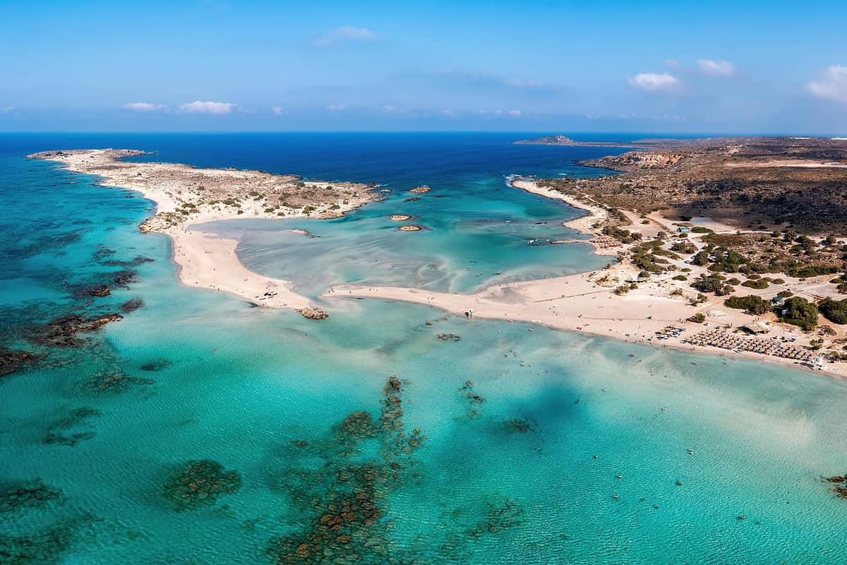
An Elafonisi day trip is a road trip across western Crete to the pink-sand beach and islet at the island’s southwest tip. It is one of the Greece tours from Chania and Rethymno.
What is an Elafonisi day trip?
An Elafonisi day trip is a road trip from a Cretan town to Elafonisi, an island near the southwestern corner of Crete. The island is known for its beaches of pink sand. The day passes on the sand and in the shallow sea.
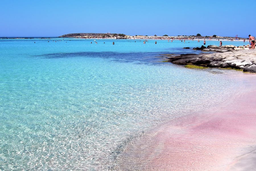
The island’s Greek name is Ελαφονήσι, which translates into English as “Deer Island”. Elafonisi is the same word written in Latin letters. In ancient times, the place went by another name, the Musagores Islands. An Elafonisi day trip therefore visits a spot whose name reaches back to the ancient world.
For local government, Elafonisi falls under the municipality of Kissamos. Kissamos in turn sits inside the regional unit of Chania. Reaching it means a road journey across the western end of Crete, from the north-coast towns down to the southwest shore. An Elafonisi day trip then spends the rest of the day by the sea.
Makeshift facilities for tourists stand in the area. Beach umbrellas and sunbeds are set out on the sand. Visitors on an Elafonisi day trip find shade and a place to rest between swims. The setup stays simple, which keeps the focus on the sand and the clear, shallow water.
- Popular spot: Crete counts Elafonisi among its popular tourist attractions.
- Island company: The other islands on that list of attractions are Chrysi, Gramvousa and Spinalonga.
- Setting: Crete itself is a Mediterranean island, the much larger neighbour of this small one.
An Elafonisi day trip pairs a drive across western Crete with a full day beside the sea. The pink sand draws the crowds, while the old names and the quiet southwest coast give the outing extra depth.
Which towns does an Elafonisi day trip leave from?
An Elafonisi day trip begins in one of three Cretan towns: Chania, Rethymno or Heraklion. Visitors either join a coach tour or drive the whole route by hired car. The choice of starting town decides how much of the day goes on the road.
Chania, a Cretan city, is the seat of the Chania regional unit. The unit takes in the island’s westernmost quarter. Elafonisi lies just over 70 kilometres from the city. For an Elafonisi day trip, this makes Chania a sensible place to stay on the night before.
Rethymno is the second of the three towns where these day trips begin. Chania, on Crete’s northwest coast, sits roughly 70 kilometres from Rethymno, which lies to its east. The Chania regional unit borders just one other regional unit. That single neighbour is Rethymno, which lies to the east of the Chania unit.
The port of Kissamos lies 41 kilometres to the west of Chania. The regional KTEL bus service links Kissamos with Chania and also with Elafonisi. This gives travellers without a car a second place from which to start the journey. An Elafonisi day trip by bus can therefore start from Kissamos as well.
- Chania by bus: Buses run to Elafonisi from Chania, giving an option beside organised coach tours.
- Heraklion: The city of Chania lies about 145 kilometres to the west of Heraklion.
- Chania’s past: In 1898 the Great Powers chose Chania as the seat of government for the Cretan State, then semi-autonomous.
In 1971, Heraklion took over as the capital of Crete. Visitors who base themselves in the modern capital still have the option of an Elafonisi day trip. The key step is to pick a starting town first, then book the transport that suits it.
Which villages does an Elafonisi day trip pass in western Crete?
An Elafonisi day trip crosses the Inachori district of western Crete, a name that means “nine villages”. Elos lies right on the road to Elafonisi, 57 km from Chania. Kefali, Vathi and Strovles are neighbouring villages of the same district.
Elos is built on the slope of Agios Dikaios hill. The village stands 560 metres above sea level. A forest of chestnut and plane trees surrounds it. Travellers on an Elafonisi day trip pass this green hillside before the road reaches the sea. The wooded slope is a clear change from the sandy coast.
In Kefali, the Transfiguration church holds a treasure of Cretan religious painting. Well-kept frescoes still survive inside it. Two different workshops painted them, so the paintings show the hands of two separate teams. Visitors with an interest in church art can look for the differences between the two groups. The mix rewards a slow look.
Vathi is another village of the Inachori district. Its Agios Georgios church dates from 1284, when it was built and painted. The monk Iakovos paid for the work. A stop in Vathi adds a medieval chapter to an Elafonisi day trip. The church shows that faith and art reached these hills long ago.
- Kefali: This village is built at an altitude of 400 metres above sea level.
- Vathi: The village lies at an altitude of 320 metres in the same group of villages.
- Strovles: This village lies 55 km from Chania and is built at 450 metres.
Since the 1960s, Elos has marked late October with a yearly chestnut festival. An Elafonisi day trip in late October can meet the village at festival time. The yearly event shows the place the chestnut holds in everyday village life.
What tints the beach pink on an Elafonisi day trip?
An Elafonisi day trip reveals sand with a pink colour along the shore. The colour comes from coloured microorganisms in the sea. Tides and waves carry these tiny living things onto the beach. There, they mix with the sand grains and tint them pink.
These pigmented microorganisms do not live alone. They form a symbiotic partnership with the seaweed native to Elafonisi. The seaweed and the tiny organisms live side by side. The pink seen on an Elafonisi day trip is paler than in the past. Today it holds only about 10% of the strength it had in the early twentieth century.
Pink sand like the shore on an Elafonisi day trip also appears in other parts of the world. Budelli is an island of the Maddalena archipelago in northern Sardinia, Italy. Its beach, Spiaggia Rosa, gets its colour from tiny coral fragments. Shells of Miriapora truncata and Miniacina miniacea also add to the pink tone there.
Bermuda offers a second example with a different source. There, a foram called Homotrema rubrum has a strong red colour. Surf grinds this organism into pieces the size of sand grains. Those red pieces mix into the shore and give Bermuda’s beaches a pink tint. Each red fragment began as part of a living organism.
- Full name: Forams is the short name for foraminifera, a group of single-celled organisms.
- Meaning: The Latin name foraminifera means hole bearers when translated into plain English.
- Size: A typical foram measures under 1 mm across, yet the largest species reach 20 cm.
Visitors used to carry the pink sand away as souvenirs. A Greek government ban now forbids its removal from the beach. Visitors on an Elafonisi day trip today leave every grain on the shore. The pink sand stays in place for the next visitors.
What does the shallow lagoon add to an Elafonisi day trip?
An Elafonisi day trip gains a walk through the sea itself. In fine weather, visitors can wade across the shallow water to reach Elafonisi island. The lagoon turns a simple beach stop into a crossing from one shore to another.
Elafonisi island lies about 150 metres off the facing Cretan shore. A shallow channel fills the space in between. On an Elafonisi day trip, this channel forms the link between the mainland beach and the island. The gap looks small, yet the far side brings a fresh view of the coast.
Shallow and enclosed, a lagoon is water that a narrow strip of land separates from the sea beyond. Coastal lagoons stay shallow because the coast around them slopes gently. Along such a coast, the water deepens slowly as people move out from the shore. That gentle gradient suits wading and paddling.
Water temperature follows simple rules of the sea. Shallower water lying over a continental shelf runs warmer than the deeper sea. Light wind and strong daytime sunshine also build a warm layer at the surface. For an Elafonisi day trip, these rules point to a calm, bright day as the better choice.
- Tombolo: A tombolo is a deposited landform, a narrow spit or bar joining an island to the mainland.
- Shifting shape: Tombolos change shape and size with tides and weather more than an ordinary beach does.
- Marine area: The marine part of the Elafonisi site takes in sand drifts, shallow coves and reefs.
Tourists come to the Inachori area for the white sand beach and the warm, shallow water at Elafonisi. Those two draws sit at the heart of an Elafonisi day trip. The lagoon ties them together, turning a swim and a beach walk into one outing.
What does the islet show on an Elafonisi day trip?
An Elafonisi day trip leads visitors onto a long and narrow islet. It stretches 1,500 m in length and reaches 500 m in width. Its compact shape keeps the main sights close together, so visitors can reach each of them on foot.
The western side of the islet is rocky and climbs to a high point of 39 m. The rest of the islet is mainly sandy lowland, soft underfoot. Walkers on an Elafonisi day trip meet two kinds of ground. The rocky west feels wild, while the sandy lowland feels calm and open.
A large wooden cross stands on the islet. It marks a shipwreck that took place on 22 February 1907. The lost vessel was the Imperatrix, an Austrian passenger steamer. The cross gives the open landscape a clear human story. It invites a quiet, thoughtful pause on any Elafonisi day trip.
In strong northwest winds, 38 people died in a lifeboat while trying to reach the shore. Below the islet’s cliffs, the Imperatrix wreck still lies on the seabed. Visitors looking out to sea from this spot face the final resting place of the old steamer. The scene feels serious.
- Origin: The loss of the Imperatrix was the reason a lighthouse rose on a hilltop of the islet.
- Setting: A lighthouse stands on the western tip, which is made of raised limestone.
- Wartime loss: Occupying German troops destroyed the lighthouse during the Second World War.
Sand dunes dominate the long beach that runs along the islet. They frame the shore with soft, rolling shapes and give the coast an open look. An Elafonisi day trip ends well with a slow walk past these dunes, where sand and sea meet.
Which tragedy does an Elafonisi day trip recall?
An Elafonisi day trip recalls a grim and painful chapter of Cretan history. On Easter Sunday, 18 April 1824, Ottoman soldiers killed hundreds of Greeks on this islet. The victims were chiefly women and children. Their loss still marks the story of this quiet shore.
In 1821, Christians in Crete rose up in revolt. The Ottoman reply was fierce and included the execution of bishops. The next blow came by sea. In 1822, a large Egyptian fleet sailed into Souda Bay. It counted 30 warships and 84 transports. This background gives an Elafonisi day trip deeper meaning.
After Hasan died in February 1823, Hussein Bey took command. He led 12,000 Turkish-Egyptian soldiers into the field. Artillery and cavalry marched with his men. Hussein then pressed hard against the Cretan rebels. By spring 1824, he had pushed their resistance back into a small number of mountain enclaves.
Forty armed men sought shelter on the islet. Women, children and old folk came with them. All hoped to escape the advancing Ottoman troops. On Elafonisi, the refugees waited for a ship. It was to carry them to the Ionian Islands. Visitors on an Elafonisi day trip stand where they waited.
- Discovery: One soldier’s horse walked through the shallows to the island, and the hiding people were found.
- Numbers: Between 640 and 850 people had gathered on the islet at that time.
- Fate: Those who were not killed were sold into slavery in Egypt.
Today, a plaque on Elafonisi’s highest point recalls this tragic event. A walk up to the plaque adds a moment of quiet respect to an Elafonisi day trip. Visitors can stop there in silence before walking back down to the water’s edge.
Which legal protections apply on an Elafonisi day trip?
An Elafonisi day trip enters Natura 2000 site GR4340002. That protected site covers Elafonisos Island and its coastal sea zone. Elafonisi and the facing coast also hold a second listing. They form a Landscape of Special Natural Beauty, listed under the code AT6011066.
NECCA, the state agency for nature and climate change, runs its Western Crete protected areas unit from Chania. That unit lists the Elafonisi Natura site among its protected areas. The site spans 271.75 hectares in total. Of that area, 39.95 hectares are land. Beach time on an Elafonisi day trip takes place inside this listed area.
The landscape listing has a legal status of its own. That status includes three separate labels. The first marks the area as an archaeological site. The second marks it as a historic site. The third names it an area of special state protection. All three labels cover Elafonisi and the facing coast.
Tourism places the fragile ecosystems of the Elafonisi site under heavy pressure. That pressure comes from five sources. Camping and trampling are the first two. Vehicles add a third. Waste dumping and plant removal complete the list. With simple care, visitors on an Elafonisi day trip avoid adding to any of the five.
- Coastal site: The Western Crete unit lists the beach from Chrysoskalitissa to Cape Krios as site GR4340015.
- Reserve status: The Greek government declared Elafonisi a nature reserve.
- Dune rule: Because of that reserve status, visitors are asked to stay off the dunes.
The dunes at Elafonisi matter for one more reason. Rare biological communities form part of those dunes. That type of dune formation is growing rarer. Sand removal is one cause of the decline. Hotel building adds to the same decline.
Which plants and animals live along an Elafonisi day trip?
An Elafonisi day trip crosses a long beach where sand dunes dominate the shore. A well-developed community of dune grass (Ammophila arenaria) covers these dunes. Migratory birds also treat the whole area as a very important place to rest and breed.
Flowers also grow in this sand. A significant population of sea daffodils (Pancratium maritimum) lives in the dune zone of the beach. An Elafonisi day trip therefore passes close to an important flower habitat. Staying off the dunes leaves these plants undisturbed. Walkers who keep to the open beach protect their home ground.
Behind the dune grass, the sands carry thickets of a juniper called Juniperus oxycedrus ssp. macrocarpa. Birds have a clear role in the life of these thickets. They eat the juniper cones and later pass the hard seeds in their droppings. In this way, birds spread the seeds of this juniper.
Two rare plants tie Elafonisi to a small group of EU sites. Androcymbium rechingeri and Ipomoea stolonifera still exist here, at one of 100 or fewer such sites. For the first, the Natura 2000 record counts 350,000 individual plants on the site. An Elafonisi day trip crosses ground that matters for both species.
- Rocky coasts: Two rock-dwelling plants, Crithmum maritimum and Capparis orientalis, grow on the rocky coasts of Elafonisi.
- Coastal growth: Euphorbia dendroides, a third rock-coast plant, shares these same stony stretches of shore.
- Fig: The fig (Ficus carica) also takes root along the rocky edges of the coast.
The sea daffodils keep one more quiet detail. Their flowers carry a subtle lily scent, yet it shows only on still, windless summer nights. Visitors on an Elafonisi day trip come in daylight, so the soft perfume stays out of reach.
Why visit Chrysoskalitissa Monastery on an Elafonisi day trip?
An Elafonisi day trip can include a stop at Chrysoskalitissa, a Greek Orthodox monastery. It stands on the mainland, about five kilometres from Elafonisi island. The visit adds faith, history and local legend to a day otherwise spent on the beach.
Chrysoskalitissa lies about 72 kilometres southwest of the city of Chania. The monastery is built on rocks that rise 35 metres above sea level. That raised position gives the site a clear view of the shore around it. For an Elafonisi day trip, the rock adds a change of scene from the beach.
Local tradition links the name Chrysoskalitissa to one of the ninety steps up to the main building. Tradition calls that step golden, after chrysos, the Greek word for gold. The name itself carries a story about the climb. Each step up the stairs becomes part of the old tale.
Faith and history meet at this point on the coast. Its dedication is twofold: the Holy Trinity, and the Virgin Mary’s Dormition. Digs on the nearby coast revealed Early Minoan and late Neolithic settlement remains. An Elafonisi day trip that stops here touches both church history and early island life.
- Built era: Chrysoskalitissa dates from the 17th century and sits on the southwest coast of Crete.
- Sea view: From its rock, the monastery faces the Libyan Sea.
- Golden step legend: Legend says only devout Christians are able to see the golden step on the stairs.
Small-group and expert-led trips differ in their stops, so the monastery is not on every route. Travellers who want it on their Elafonisi day trip can confirm the stop with the host before booking. That way, the day joins faith and history with time on the shore.
What does the Topolia Gorge add to an Elafonisi day trip?
An Elafonisi day trip by road passes through the Topolia Gorge. The gorge runs from Topolia to Koutsomatados, along the road to the Nine Villages and Elafonisi. It is 1.5 km long, with sheer walls that rise up to 300 metres.
The gorge opens just south of the village of Topolia. Topolia lies 46.5 km from Chania and is built at an altitude of 280 metres. Travellers on an Elafonisi day trip by road reach the village before the gorge. From there, the scenery changes quickly from village streets to tall rock walls.
The road runs along the western walls of the gorge. A small road tunnel was cut into the rock to let it pass. Between the walls, the bed of the gorge is 5 to 50 metres wide. Plane trees fill this bed, so a band of green runs along the gorge floor.
The gorge walls hold caves, and Agia Sofia stands out among them. A small church sits beside its entrance. Inside is a large hall 20 metres high. Stalagmites and stalactites decorate the hall. Not every Elafonisi day trip stops at the cave, so travellers keen to see it check the itinerary.
- Easter feast: The Agia Sofia chapel in the west wall celebrates its feast on the third day of Easter.
- Plant life: Wild olives and strawberry trees grow in the gorge, which has rich plant life.
- Animal life: Hares and birds are part of the rich animal life found in the gorge.
In Topolia itself, the two-aisled church of the Holy Cross and Agia Paraskevi has well-kept frescoes inside. Together, the village, the cave and the gorge add interest to the drive. The drive becomes a sight in its own right on an Elafonisi day trip.
Which nearby beaches line an Elafonisi day trip?
An Elafonisi day trip reaches a western Cretan coast where pebble beaches and sandy strips sit close together. Krios beach lies ten kilometres west of Paleochora. Elafonisi beach lies farther west, about 18 kilometres from it. Each stretch offers a different mix of sand and stone.
Paleochora has two contrasting beaches on either side of the settlement. Pebbly Chalikia beach lies to the east. Sandy Pachia Ammos stretches westward for about one kilometre. Travellers planning an Elafonisi day trip from this end of the coast can visit both shore types. The choice comes down to stones or soft sand.
Habitats on the protected coast towards Cape Krios include two kinds of juniper growth. The first is dune juniper thickets, which grow on the sand. The second is tree-like juniper scrub, where shrubs take the shape of small trees. Visitors on an Elafonisi day trip who walk this shore can spot both habitats.
Falasarna is another stretch of coast that travellers in western Crete can add. It lies 59 kilometres west of Chania and 12 kilometres west of Kissamos. A poll once voted its beach into a world list of 100 top beaches. The vote placed this Cretan shore on a worldwide list.
- Coastline: Falasarna’s shore forms a 5 km belt, part sand and part rock, with salt-tolerant plants on the sand.
- Organised beach: An organised beach known as Pachia Ammos lies close to the ancient city at Falasarna.
- Ancient remains: Visitors to ancient Phalasarna can see sandstone towers, bastions, long fortification walls and a closed harbour.
Site notes urge care for the Cretan shore that faces Elafonisi. They name its cedars and pink sand as part of the beauty worth keeping. Travellers on an Elafonisi day trip help that goal by leaving the cedars and sand untouched.
What does Kissamos show on an Elafonisi day trip?
On the road from Chania, an Elafonisi day trip passes Kissamos, a harbour town on the route. Its other name, Kastelli, recalls a Venetian castle that stood there long ago. A stop here adds a working port, a museum and views over the bay.
Kissamos works both as a port and as a fishing harbour. A regular ferry connects the town with the Peloponnese by way of Kythira. For travellers on an Elafonisi day trip, the harbour shows the working side of the coast. A short walk beside the moored boats breaks up the drive.
The Archaeological Museum of Kissamos sits in the old Venetian-Turkish governor’s building. That building lies inside Kastelli’s castle, within the old Venetian perimeter. Under Ottoman rule, this perimeter was strengthened. The building therefore carries traces of two ruling powers. Travellers who step inside find the town’s past laid out room by room.
Kissamos has a long past as a port. After Rome destroyed Phalasarna in 69–67 BC, Kissamos became the main port of Polyrrhenia. The museum’s largest room presents the town villas of Greco-Roman Kissamos. This display helps travellers picture the ancient town. The visit adds a layer of history to an Elafonisi day trip.
- Room displays: The largest room shows mosaic floors, opus sectile work, a sundial, table supports and sculptures.
- Bay: The Gramvousa Peninsula forms the western side of Kissamos Bay, the town’s own stretch of sea.
- Balos boats: In summer, boats leave the port of Kissamos daily, carrying visitors to Balos beach.
The town community of Kissamos counts 4,321 residents, a modest size for a working port. An Elafonisi day trip that pauses here meets everyday life in a lived-in coastal town. From the harbour, the road then carries on towards Elafonisi.
Which season suits an Elafonisi day trip?
An Elafonisi day trip suits summer best for beach time, but a winter visit still works. Palaiochora is the nearest weather station to Elafonisi on the south coast. Its summers run hot and dry, while its winters stay very mild, so both seasons have appeal.
Summer brings real heat to this corner of Crete. At Palaiochora, the average daily high climbs to 33.1 °C in July. Rain almost vanishes, with just 0.2 mm falling on average that month. Days like these call for shade, water and regular swims to cope with the midday sun.
Sunshine is a strong reason to plan an Elafonisi day trip. Each year, south Crete receives over 3,257 hours of sunshine. That is the highest total in Greece. Clear skies suit photographers who want bright shots of the sea and sand. Visitors hoping for a sunny beach day have good odds here.
Swimming is the main draw of a summer Elafonisi day trip. Around Gavdos, the sea keeps its warmth and passes 26 °C in summer. That reading gives swimmers in the region a useful hint. Water that warm suits long swims and calm paddling for young children. Snorkellers also stay in longer without feeling cold.
- Peak sunshine: The Chania Airport station at Souda averages 376.7 hours of sunshine in July.
- Mild January: In January, Palaiochora’s average daily high still holds at 16.1 °C.
- Wet December: December at Palaiochora brings an average of 114.0 mm of rain, so a rain jacket helps.
Autumn offers a softer option for an Elafonisi day trip. October at Palaiochora still brings an average daily high of 25.0 °C. That warmth suits a picnic and a slow walk along the shore. For those who dislike strong heat, October is a sound choice.
Which Cretan foods fit an Elafonisi day trip?
An Elafonisi day trip opens the door to Cretan food, from savoury bites to local cheeses and spirits. In the Chania region, cooks make salty kalitsounia stuffed with local mizithra. Another version of these salty kalitsounia is stuffed with Cretan herbs instead.
Dakos is one dish that travellers on an Elafonisi day trip can look for. The dish also goes by a second Greek name, koukouvagia. This word literally means ‘owl’. Knowing both names helps a visitor spot the dish under either label on a menu. Such a name makes the dish easy to remember.
Cooks make staka by heating sheep’s milk cream with wheat flour or starch over a low flame. Cooks use staka butter in Cretan pilaf, which is commonly served at weddings. Another speciality of Cretan cuisine is gamopilafo, rice simmered in a broth of goat and rooster. Sheep, goats and roosters all feature in these dishes.
Cretan cheese is an easy food to carry on an Elafonisi day trip. Among the island’s cheeses, graviera of Crete is a good one to try first. It tastes a little sweet, with notes of burnt caramel. A slice with fresh bread makes a simple snack between swims in the sea.
- Protected cheese: Xynomizithra of Crete holds a registered EU protected designation of origin.
- Chestnut country: The rugged and remote Inachori area is known for its chestnuts.
- Local spirit: Tsikoudia goes through a single distillation, unlike related grape spirits that are double-distilled.
Cretan food also carries an interesting health story. Ancel Keys studied 12,000 men in seven different countries. He said Cretans had the lowest chance of getting cardiovascular disease. That finding gives extra interest to a simple Cretan meal after an Elafonisi day trip.
What geology shaped the coast on an Elafonisi day trip?
An Elafonisi day trip follows a coast shaped by earth movement and wind. Offshore, the Hellenic Trench runs close to the south shore of Crete. Great earthquakes, rising land and drifting sand all help explain the scenery along this part of Crete.
Along the Hellenic arc, the ground has shaken with great force. This arc hosted two major Crete earthquakes, in the years 365 and 1303. Each one is thought to have reached about magnitude 8 or more. Earthquakes on that scale release enormous energy. The coast of Crete still carries signs of the first one.
The 365 earthquake is thought to have raised the island of Crete by nine metres (30 feet). A lift of that size pushes old shorelines clear of the water. Rock that once met the waves ends up high and dry. An Elafonisi day trip crosses land thought to have sat lower before that shock.
In 1859, Spratt found the old harbour of Falasarna 100 yards inland. Its ancient coastline had risen by at least 24 feet. A harbour needs open water, so a dry one is clear proof of uplift. For visitors on an Elafonisi day trip, the find shows how far a shoreline can move.
- Coral clues: Uplifted coastal corals suggest the 365 tsunami began at a steep fault in the Hellenic Trench near Crete.
- Island rock: The limestone on the Elafonisi islet belongs to the rock unit known as the Gavrovo-Tripolis series.
- Trench end: From Crete, the Hellenic Trench runs on until it ends near Rhodes, off Anatolia.
Dunes form where a wide beach lets blown sand pile up. Onshore winds also push that sand inland, away from the water. Anyone on an Elafonisi day trip can watch for this pattern where the beach meets the land.
What questions come up about an Elafonisi day trip?
An Elafonisi day trip raises four common questions. Visitors ask what a Blue Flag award means for a beach. They also ask how strong wind changes the sea. Weever fish stings and heat exhaustion in summer complete the list of safety concerns for visitors.
What does a Blue Flag award mean for an Elafonisi day trip?
The Blue Flag trademark belongs to the Foundation for Environmental Education, known as FEE. FEE is a not-for-profit, non-governmental organisation. Its award criteria cover quality, safety, environmental education and information. Services and environmental management are also part of the list. The award was officially created in France in 1985.
How does strong wind affect an Elafonisi day trip?
The sirocco is a Mediterranean wind. In southern Europe, it can reach hurricane speeds. Wind and breaking waves push surface water towards land, and this forms a rip current. Swimmers leave one by swimming at a right angle to the flow. This means swimming parallel to the beach.
How is a weever fish sting treated on an Elafonisi day trip?
By day, weevers bury themselves in the sand, leaving only their eyes in view. First aid for a sting means soaking the area in hot water, short of scalding. Once the pain eases, the wound is checked for broken spines. Any spines found are then removed from the skin.
How can heat exhaustion be handled on an Elafonisi day trip?
The NHS lists light-coloured, loose clothing as one way to help prevent heat exhaustion. Warning signs include excessive sweating and skin that turns pale and clammy. An isotonic sports drink or oral rehydration powder helps replace salt lost through sweating. Both are simple to pack before an Elafonisi day trip.