
A Kavala day trip is a visit to the port city of Kavala in northern Greece and the ancient places around it. It sits among the Greece tours that join old cities, ruins and the sea.
What is a Kavala day trip?
A Kavala day trip is a visit to Kavala, a city in northern Greece. Kavala is the principal seaport of eastern Macedonia. That makes it a port city, set beside the sea. A seaport is a harbour town where ships load and unload.
The city lies on the Bay of Kavala. A bay is a place where the shore bends inward and holds the sea. Across the water from the city sits the island of Thasos. A Kavala day trip therefore happens beside the sea, with the coast and the island as the setting.
Long ago the town went by the name Neapolis, which means new city. In the Early Middle Ages it was renamed Christopolis, meaning city of Christ. The modern name Kavala has been used from the 16th century onward. Each name belongs to a different age in the story of the same place.
Settlers from Thassos, an island, founded the city in the late 7th century BC. Settlers are people who move somewhere new to build a community. BC after a year shows that it falls before the first year of the common calendar. A Kavala day trip thus reaches a city whose roots go back to island settlers.
- Capital: Kavala is the seat of the Kavala regional unit, an official district of Greece.
- Population: The census of 2021 counted 66,376 people living in the municipality of Kavala, its local government area.
- Gateway: Since ancient times, Kavala has been a vital gateway between Europe and the Middle East.
Today the city carries the nickname the cyan city. Cyan is a colour between blue and green. In short, a Kavala day trip means time in a northern Greek port. That port has a long past and a colourful nickname.
What does the Kavala Fortress and old town add to a Kavala day trip?
A Kavala day trip meets Byzantine and Ottoman history at the fortress and in the old town. A fortress is a strong, walled building made to defend a place. Panagia, the old town, has colorful local architecture, winding cobblestone alleys and traditional tavernas climbing the peninsula.
Emperor Justinian I fortified Kavala in the 6th century to protect it from barbarian raids. A Greek inscription, which is a text carved into stone, sits on a defensive tower of the fortifications. It dates from about 830–840 AD and remains visible to visitors on a Kavala day trip.
Emperor Andronikos III Palaiologos built a new long defensive wall to keep the Catalans from returning. Byzantine refers to the eastern part of the old Roman world in the Middle Ages. The Ottomans later made the Byzantine fortress on Panagia hill larger. On a Kavala day trip, the walls show the work of more than one ruler.
Excavations found the ruins of an early Byzantine basilica beneath an Ottoman mosque in the Old Town. A basilica is an early church built as a long hall. A citadel is the strongest inner part of a fortress. The Byzantine citadel crowns the highest point of Panagia and is described as giving a full circle of outlook over the Aegean Sea.
- Imaret position: The Imaret complex was built just below the fortifications, inside the centre of the old town.
- Imaret foundations: It stands on top of earlier Byzantine walls on the Panagia peninsula.
- Imaret size: The complex is 120 metres long and covers an area of 4,200 square metres.
Muhammad Ali’s house in Kavala has been preserved as a museum. It adds the story of a family home to the stories of walls and towers. A Kavala day trip therefore shows history told through defences, public buildings and daily life.
What does the Kamares aqueduct add to a Kavala day trip?
A Kavala day trip can include the Kamares, which is the popular name of the Kavala aqueduct. Kamares is a Greek word that means arches. An aqueduct is a stone channel built to carry water across land. The Kamares is one of those channels.
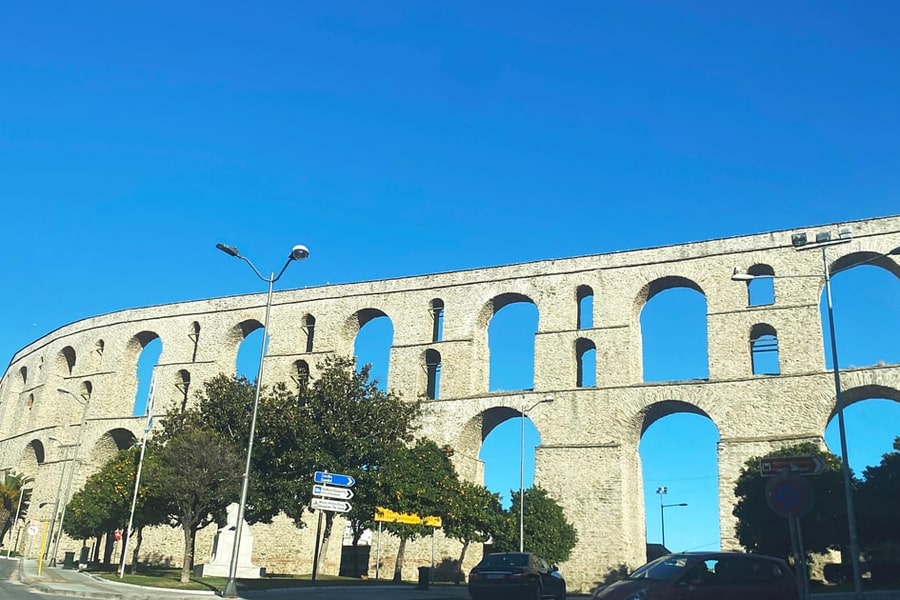
The Kamares is an Ottoman aqueduct, and it divides the old and new parts of Kavala. A Kavala day trip can use the arches as a marker between the two areas. The structure stands in the city itself. It counts as one of the city’s landmarks, so it is easy to place on a map.
Before the arches, a Byzantine barrier wall stood on the Acropolis. Acropolis is a Greek word for the high part of a city. That wall dates from the early 14th century. Historians think it also carried water. Suleiman the Magnificent then repaired the fortifications, and the repair replaced the wall with the present arched aqueduct.
Researchers lean toward a date between 1530 and 1536 for the arched aqueduct itself. Ibrahim Pasha, Grand Vizier of Suleiman the Magnificent, reconstructed the late Roman aqueduct. A Grand Vizier was the chief minister of the Ottoman ruler. A Kavala day trip therefore links one name to one rebuilding.
- Roman roots: The aqueduct is of Roman origin, so its history reaches back to ancient Rome.
- Ottoman work: The Ottomans built the present aqueduct structure in the 16th century.
- Condition: The aqueduct is well preserved, so its arches can still be studied today.
The aqueduct once did real daily work for the city. It supplied Kavala with drinking water from Mount Pangaeus until as late as 1911. For that reason, a Kavala day trip shows the arches as a working part of city life.
Who was Muhammad Ali behind a Kavala day trip?
A Kavala day trip is a chance to meet the story of Muhammad Ali. He became the de facto ruler of Egypt from 1805 to 1848. De facto is Latin for in fact: he held the real power, whatever his title.
A Kavala day trip brings up the family of Muhammad Ali. As a boy, he moved with them from an Albanian village to the Sanjak of Kavala. A sanjak was an Ottoman district. His father, Ibrahim Agha, was a tobacco and shipping merchant and a unit commander in Kavala.
His uncle gave him the rank of Bolukbashi, an army title, for collecting taxes in Kavala. He served in the Kavala Volunteer Contingent. This Albanian force was sent to re-occupy Egypt after Napoleon, the French leader, withdrew. A Kavala day trip links his work as tax collector and soldier to the region.
In 1805 he was named governor of Egypt. He also received the rank of Pasha, a high title in the Ottoman system. He invited the Mamluk leaders, a ruling military class of that age, to a celebration. It took place at the Cairo Citadel, a walled fortress, and honoured his son Tusun Pasha.
- Reach: In 1840 his rule reached Egypt, Sudan, Crete, Cyprus and parts of Greece.
- Dynasty: His dynasty, meaning his ruling family, held Egypt for over a century, until the revolution of 1952.
- House: His house in Kavala has been preserved as a museum.
The Mehmet Ali Pasha House Museum is described as a well-preserved Ottoman mansion from the 18th century. Ottoman means linked to the empire that ruled the region in that period. A Kavala day trip gives that history a real place in the town.
What does Philippi add to a Kavala day trip?
A Kavala day trip can include Philippi, an ancient city that lay roughly 13 km from Kavala, toward the north-west. The site holds the remains of a Greek and Roman town. The outing adds ancient history to the area and gives the visit a clear focus.
Philippi began life under an earlier name, Crenides. Thasian colonists founded that first settlement in the ancient region of Thrace in 360/359 BC. Colonists are settlers who leave home to build a new town. A Kavala day trip that reaches the site meets a story with Greek roots. That story begins well before Roman rule.
Excavated remains include walls, a Greek theatre and a house foundation under the Roman forum. A foundation is the base a building rests on. The forum was the open public square of a Roman city. Romans enlarged the theatre to host Roman games. These layers show how builders reshaped one place over time.
In 42 BC, Antony and Octavian defeated the Republic’s supporters at the Battle of Philippi. The Republic was the Roman state before emperors ruled it. The battle belongs to the political history of Rome. The battle carries the city’s name. A Kavala day trip therefore links local ruins to the wider story of Rome.
- Forum: The Roman forum sat on two terraces on either side of the main road.
- Basilica: A pavement mosaic inscription names the Basilica of Paul, a large church hall, dated to about 343.
- Churches: Seven churches rose in Philippi between the mid-4th century and the end of the 6th.
In 2016 UNESCO added the archaeological site to its World Heritage list. That list names places that matter to all people. For a Kavala day trip, the listing makes Philippi a sound choice. It suits anyone who enjoys history and ancient places.
Which battle was fought near a Kavala day trip?
A Kavala day trip leads near the site of the Battle of Philippi. It was fought in the year 42 BC at Philippi, an ancient city in Macedonia. It was the final battle of the Roman civil war, with Antony and Octavian against Caesar’s assassins.
The battle was two separate engagements, meaning clashes between armies. Both were fought on the flat land lying to the west of that ancient city. In the first one, Brutus faced Octavian, while Antony fought Cassius. Anyone planning a Kavala day trip can use this plain to picture the two armies there.
Cassius died by suicide after hearing a false report about Brutus. Apart from his death, the first engagement was essentially a draw. In plain words, neither army had clearly won. The report was false, so the news that moved Cassius was wrong. The fight stayed even for both of the armies on that day.
The Liberators, the camp of Caesar’s assassins, held high ground along the Via Egnatia. The high ground lay 3.5 kilometres west of Philippi. In plain words, Via Egnatia is Latin for the Egnatian Road. A reader of a Kavala day trip plan can mark that distance on a map of the plain.
- First engagement: This general battle took place on 3 October 42 BC on the plain.
- Second engagement: The clash on 23 October finished off Brutus’s forces for good.
- Aftermath: Philippi became a Roman colony, a town settled under Roman rule, after the victory.
Brutus then took his own life. That left the triumvirate, the ruling group of three men, in control of the Roman Republic. A Kavala day trip story about Philippi therefore ends with the close of a civil war among Romans.
Who was Lydia behind a Kavala day trip?
A Kavala day trip can lead to the story of Lydia of Thyatira. Accounts name her as the earliest recorded convert to Christianity in Europe. The book of Acts, in chapter 16, describes her as a seller of purple. Purple here means cloth dyed purple.
The name Lydia means the Lydian woman. That shows she came from Lydia, a region in Asia Minor. Asia Minor is the old name for the western part of present-day Turkey. Her name works like a label for her home. Anyone planning a Kavala day trip meets that detail early in her story.
Lydia was living in Philippi, in Greek Macedonia, when she met Paul and his companions. Her household was baptized, which means they were welcomed into the Christian faith with water. Lydia then begged Paul’s party to come and stay in her house. That welcome gives a Kavala day trip a warm human thread.
Paul is believed to have preached on European soil for the first time in Philippi. The New Testament, the collection of early Christian writings, records his visit during his second missionary journey. A missionary journey is a trip made to spread a religious message. The record ties Lydia to a clear moment in history.
- Origin: Thyatira was a city in the ancient region of Lydia, now called Akhisar in Turkey.
- Catholic title: The Catholic Church named her the patroness of dyers, a title linked to her cloth trade.
- Orthodox title: The Orthodox Churches give her the title Equal to the Apostles.
A modern baptistry stands on the traditional site in Krynides where Paul baptized Lydia. A baptistry is a building or place used for baptism. This spot ends the Lydia chapter of a Kavala day trip with a real landmark.
What does Thasos add to a Kavala day trip?
A Kavala day trip can include Thasos, the farthest north of the major Greek islands and twelfth in size by area. The island lies 20 kilometres south-east of Kavala. The two places sit close together on the map of northern Greece and its coast.
Thasos covers 380 km2 and has about 13,000 inhabitants, so the island is compact. Its outline is round, with no deep bays and no big peninsulas anywhere. A peninsula is a long arm of land reaching into the sea. A Kavala day trip meets one simple shape, not a long and ragged coast.
Thasos sits about 7 km from the northern mainland, so the open water between them is narrow. Its highest peak is Ypsario, a mountain at 1,205 metres above sea level. A mountain of that height is a clear high point above the rest of the land around it.
The rock of the island is made of gneisses, schists and marbles. Gneisses and schists are hard rocks with layers, and marble is a stone that takes a polish. These rocks belong to the Rhodope massif, a block of mountains. A Kavala day trip to Thasos deals with ground built from this stone.
- Ferry line: A ferry line links the regional centre of Kavala with Skala Prinou on Thasos.
- Old trade: In antiquity, the ancient world, Thasos was famous for its wine, nuts and marble.
- Quarry: A large marble quarry sits on a mountain near the Thracian Sea in the Panagia area.
Thasos belonged to the Kavala Prefecture until the local administration reform of 2011. A prefecture is a regional unit of government, so the island and the city once shared one administration. That old link makes Thasos a natural addition to any Kavala day trip.
What does Amphipolis add to a Kavala day trip?
A Kavala day trip can include Amphipolis, an ancient city that began as an Athenian colony. A colony is a town founded far from home by a mother city. Sparta and Athens also fought a battle at the site in 422 BC.
Archaeologists found a large tomb inside Kasta Hill in 2012. Kasta Hill is the biggest burial mound in Greece. A burial mound is a man-made hill of earth that was raised over a grave long ago. That size makes the hill a notable part of any Kavala day trip that reaches Amphipolis.
The Kasta tomb has three chambers, meaning rooms, and walls separate them. Two sphinxes stand just outside the entrance. A sphinx is a stone figure that joins a human head to an animal body. A Kavala day trip to Amphipolis can add this tomb to a plan built around ancient burial sites.
Inside the first section of the tomb, two columns that hold up the roof are carved as Caryatids. A Caryatid is a column shaped like a standing woman. Outside, the perimeter wall around the Kasta mound runs 497 metres. It is built of limestone, a common soft rock, and covered with marble.
- Lion monument: Bulgarian and British troops digging trenches in World War I uncovered parts of the lion monument.
- Wooden bridge: A wooden bridge over the Strymon, found in 1977, is a rare find for Greek antiquity.
- City wall: The northern stretch of the ancient city wall survives to a height of 7.5 metres.
A tomb under the Agora, the ancient public square, held a silver ossuary. An ossuary is a box for the bones of the dead. It held the cremated remains of Brasidas. This find links a Kavala day trip to Amphipolis with a named person.
What does the Nestos river add to a Kavala day trip?
A Kavala day trip can include the Nestos, a river that marks the boundary between the Kavala and Xanthi regional units. A regional unit is a district into which Greece divides its land for government. The river adds a natural setting beyond the city.
The Nestos rises in the Rila Mountains and flows into the Aegean Sea near Thasos. A river rises where its water first starts to flow. The river is 230 km long, and 126 km of that lies in Bulgaria. A Kavala day trip therefore touches a river whose course reaches well beyond Greece.
The river drains an area of 5,184 square kilometres, and 66% of it lies in Bulgaria. A drainage area is land whose rain and snowmelt run into one river. A square kilometre is a square of land one kilometre on each side. The longest tributary, a smaller river that feeds the Nestos, is the Dospat.
Before reaching the delta, the river crosses the Drama regional unit. A delta is flat land where a river spreads out before it meets the sea. The main stream spreads over the Chrysoupolis plain and forms freshwater lakes and ponds. This wetland, land soaked with water, gives a Kavala day trip a watery landscape.
- Gorge: The Momina Klisura gorge, a narrow valley with steep walls, is 25 km long and lies in Bulgaria.
- Ancient times: In ancient times, canyons and inaccessible mountains made the Nestos impossible to navigate.
- Name: The Nestos municipality, a local government area in the Kavala regional unit, is named after the river.
In short, the Nestos gives a Kavala day trip a story about water and land. A river that starts in distant mountains and ends at the sea shapes the places around it. That story helps explain the wider region.
What questions come up about a Kavala day trip?
A Kavala day trip raises four plain questions about the city and its setting. They cover the airport, the weather in each season, the nearby hills and the regional unit. Each answer below rests on recorded facts about the place.
Which airport serves a Kavala day trip?
A new airport opened near the town of Chrysoupoli on 12 October 1981. Its runway measures 3,000 metres in length. A runway is the long strip where planes land and take off. Kavala Airport lies 27 km, or 27 kilometres, away from the city of Kavala itself.
Which season suits a Kavala day trip?
At the Kavala Weather Station, the April average high is 18.0 °C. An average high is the mean of each day’s warmest reading. At the Kavala Weather Station, the July average high is 30.1 °C. October rainfall at the Kavala Weather Station averages 64.7 mm, meaning millimetres of rain.
Which mountain rises behind a Kavala day trip?
The Pangaion Hills lie about 40 km, or 40 kilometres, west of Kavala. Their highest point is Koutra, which stands 1,956 m high. In ancient times, people mined gold and silver in the Pangaion area. To mine means to dig a metal out of the rock and the ground.
Which regional unit holds a Kavala day trip?
The regional unit of Kavala is the easternmost part of the geographical region of Macedonia. A regional unit is a local administration area. It is divided into three municipalities, which are local government areas. The regional unit of Kavala had 116,195 inhabitants, meaning this number of people lived there.