A Nisyros volcano tour is a boat day trip from Kos to the volcanic island of Nisyros, with a walk inside its caldera. It is one of the Greece tours in the Dodecanese.
What is a Nisyros volcano tour?
A Nisyros volcano tour is a boat day trip from Kos to the island of Nisyros. The tour takes visitors down into the island’s caldera. Once inside, they walk on foot among the craters and see the volcanic ground up close.
The volcano on Nisyros is classed as a stratovolcano with a caldera. A stratovolcano is a steep cone built up from layers of lava and ash. A caldera is a large bowl that forms when the top of a volcano sinks inward. On a Nisyros volcano tour, both features shape the landscape around the walkers.
Experts class the volcano as active, though it is not erupting at present. Its craters hold fumaroles, which show that heat still rises from deep below. A fumarole is a small vent where hot steam and gas escape from the ground. In simple terms, the volcano is alive but calm.
The volcano’s striking caldera and its geothermal fields make it a singular natural landmark. A geothermal field is an area where heat from inside the earth reaches the surface. On a Nisyros volcano tour, visitors meet both features on the same walk. The walk links the shape of the land to the heat below it.
- Island group: Nisyros is part of the Dodecanese and lies between Kos and Tilos.
- Island size: The island is roughly round, about 8 km across, covering 41.6 square kilometres.
- Residents: The municipality of Nisyros had 1,048 residents in 2021, spread over 50.055 square kilometres of land.
Greece’s official tourism site highlights an active volcano and lunar landscapes on Nisyros. Here, lunar means the land looks like the surface of the moon. Both draws sit at the centre of a Nisyros volcano tour.
How does a Nisyros volcano tour reach the island from Kos?
A Nisyros volcano tour reaches the island by boat. Boat trips leave the harbour at Kamari Bay on Kos and head across the sea to Nisyros. At the end of the crossing, boats arrive at Mandraki, the island’s main town and its port.
Kos lies in the southeastern Aegean Sea. The islands of Kalymnos and Pserimos sit to its north. Nisyros sits to the south of Kos, so a Nisyros volcano tour from Kos heads south. Kos runs 42.1 kilometres in length, yet only 11.5 kilometres in width. That makes the island far longer than it is wide.
Ships reach Nisyros from three departure points: Piraeus, Rhodes and Kos. On Kos, the town of Kardamena adds daily trips during the summer season. That daily rhythm means a Nisyros volcano tour has a boat on each summer day. Visitors on Kos therefore have a regular sea link in the warm months.
Kardamena is a small town on the southern shore of Kos. It sits midway along that coast, so it lies at neither end of the island. The town is 7 km from the airport on Kos. Travellers who land by plane reach the town after a short road transfer.
- Kos Town: This town is the main port and population centre on the island of Kos.
- Kardamena: Once a small fishing village, the town has been a summer destination since the 1960s.
- Kefalos: The westernmost town on Kos lies 43 km from Kos Town.
The seafloor between Nisyros and Kos also belongs to the Nisyros volcanic complex. The volcano does not stop at the shoreline of Nisyros itself. A Nisyros volcano tour from Kos sails over part of that area before it reaches the island.
What does a Nisyros volcano tour show inside the Stefanos crater?
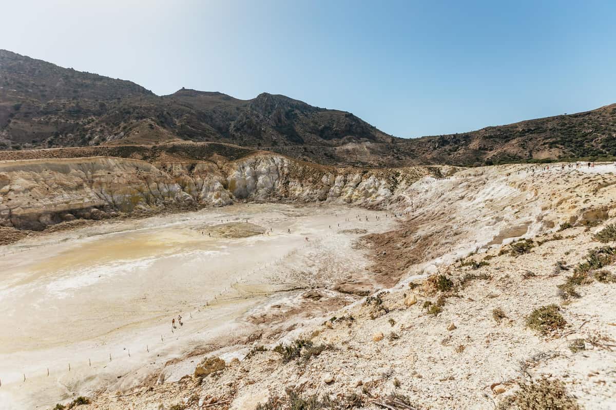
A Nisyros volcano tour shows the inside of the Stefanos crater, which measures 300 metres across. The crater shapes a 0.9 km² field of mud craters and fumaroles. Steam and gas rise from these vents across the crater floor and drift into the open air.
Superheated geothermal fluids set off hydrothermal explosions on Nisyros. Those blasts tore open the phreatic craters of the island. A phreatic crater is a pit blown open by bursting steam rather than by flowing lava. A Nisyros volcano tour turns this steam-driven past into a scene visitors see first-hand.
The crater floor is an active place. On Nisyros, the strongest fumarole activity is found in the Ramos area. The Stefanos crater stands out above all within that zone. The heat is not only in the rising steam. In the Ramos steam-vent area, the soil is just as hot as the escaping gases.
Inside the Stefanos crater, white and yellow altered rocks make up the typical view. Altered rock is stone whose make-up has changed from its first form. A Nisyros volcano tour lets visitors walk down onto the crater floor among these pale stones. The colours stand out against the steam drifting up from the ground.
- Mudpots: Mudpots, pools of bubbling mud, appear on Nisyros at Stefanos alone.
- Rainfall: The amount of rain that falls on the island sets the size of the mudpots.
- Sulphur crystals: Crystals of sulphur build up around the mouths of the holes where gases escape.
In season, the Stefanos crater receives between 200 and 1,000 tourists a day. Visitors share the crater floor with other groups on busier days. A Nisyros volcano tour shows each visitor the steam, colours and mud of this volcanic hollow.
Which smaller craters line the path of a Nisyros volcano tour?
A Nisyros volcano tour walks past the small Mikros Stefanos crater beside the main crater’s southwestern edge. From there, a path leads on to the Phlegyas crater, also known as Alexander. The same path then continues to the Mikros and Megalos Polyvotis craters.
Hydrothermal means powered by steam and hot water, not by lava. A hydrothermal crater opens when that steam and water blast through the ground. The central and southern caldera floor of Nisyros holds traces of 20 such craters. A Nisyros volcano tour crosses part of this cratered ground.
The last hydrothermal explosions on Nisyros happened in two periods. The first ran from 1871 to 1873, and the second came in 1887. Megalos Polyvotis holds clues to an earlier time. In its southern part, walkers can spot finely layered lake sediments. These thin bands are older than the 1871-1873 eruptions.
Polyvotis comes with a clear safety warning. Carbon dioxide, heavier than air, makes a stay on the Polyvotis floor unsafe when the air is still. Such a gas sinks and stays low, close to the ground. Anyone on a Nisyros volcano tour needs to follow the tour leader’s advice at this spot.
- Ramos vents: In the Ramos area, gas escapes from hundreds of separate points in the ground.
- Gas heat: The escaping gas at Ramos reaches temperatures of up to 100.1 degrees Celsius.
- Gas mix: These fumarole vents release gas that is 94 percent water vapour and 5 percent carbon dioxide.
The craters on the path are only part of the picture. Ten hydrothermal craters on the caldera floor remain well preserved, and each one has its own name. A Nisyros volcano tour gives walkers a close look at this volcanic ground.
Which eruptions built the island on a Nisyros volcano tour?
A Nisyros volcano tour reveals an island built in stages, starting as an underwater volcano. It rose into a shield volcano, then grew into a complex cone. Its caldera, a sunken bowl, is three to four kilometres wide. The bowl took shape in the last 150,000 years.
Two major eruptions each formed a caldera. The Lower Pumice comes from the first of them. During it, rhyolitic magma, a thick melt rich in silica, burst out. A Nisyros volcano tour shows a 40 m andesitic lava flow. It came from one central vent and rings the upper caldera walls, except the southwest.
The Upper Pumice comes from the second caldera-forming eruption. It was again a Plinian-type event. Plinian means a violent blast that sends ash and gas high into the sky. The eruption’s climax left rhyolitic pumice up to 60 m thick. This pumice lies at Cape Katsouni and across the island.
Scientists place the vent of that eruption in the northwest caldera. A second collapse then formed the caldera that a Nisyros volcano tour enters today. The last magmatic activity on the island came in the Post-Caldera cycle. That cycle poured out rhyodacite lavas as recently as 15,000 years ago.
- Profitis Ilias: Among the domes of Nisyros, this one rises to a height of 698 m.
- Karaviotis: Another dome on the island, Karaviotis reaches a height of 539 m.
- Boriatiko Vouno: The third dome named here rises to a height of 437 m.
Seismic unrest struck Nisyros in 1996 and 1997. That unrest led an international team to start monitoring the volcano. The work ran under Geowarn, a project of the European Union. So the ground under a Nisyros volcano tour is ground that scientists chose to watch closely.
What does a Nisyros volcano tour show in Mandraki?
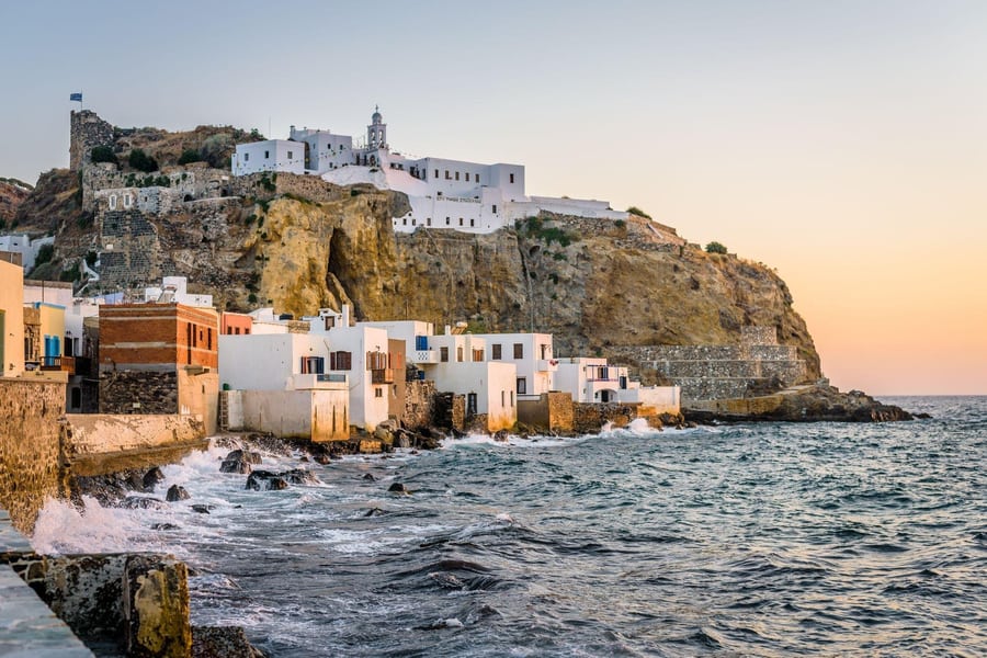
A Nisyros volcano tour shows how volcanic stone still shapes daily life in Mandraki. The houses here are built from volcanic rock and insulated with pumice stone. A walk through the village turns the volcano’s story into something visitors can touch with their own hands.
The walk through Mandraki begins in its lanes, a quiet change after the crater. White or coloured two-storey houses line both sides of each path. Wooden balconies stand out on the upper floors and face the street below. Visitors on a Nisyros volcano tour find these lanes easy to explore on foot.
Above the village, a Knights of St John castle crowns a rock 150 metres up. The castle dates from 1315. Coats of arms of the Grand Masters who built it still mark its walls. Visitors who reach the top see these old emblems up close.
Inside the castle, the Panagia Spiliani convent sits in a cave. Dating from the 18th century, it is known for its miraculous icon. Reaching it means climbing about 270 steps. The reward is a wide, open view. On a Nisyros volcano tour, this climb adds a peaceful pause after the crater.
- Ilikiomeni Square: This square has pebble-design paving, huge ficus trees, and serves as the residents’ main meeting point.
- Archaeological Museum: Its rooms display Neolithic finds from Gyali islet, dating to the 4th millennium BC.
- Folklore Museum: An 18th-century mansion here holds old vessels, costumes and handmade embroidery for visitors to study.
Mandraki had 791 residents at the 2021 count, which makes it a small community. A Nisyros volcano tour that adds this stop links the volcano to everyday island life. Visitors leave with a fuller picture of Nisyros than the crater alone can give.
Which villages on the caldera rim greet a Nisyros volcano tour?
A Nisyros volcano tour can reach two villages that stand on the caldera rim, Nikia and Emporios. Each one sits on the high edge that rings the volcanic basin. In Nikia, visitors get a panoramic view down into the crater from the village itself.
Nikia is a traditional village on Nisyros, set in a semi-mountain landscape. It stands at an altitude of 390 metres. The 2011 census recorded 61 residents there. That figure covered the community and the settlement alike. For a Nisyros volcano tour, the climb to Nikia adds a living village to the volcanic scenery.
The village square holds a pebble mosaic made in 1923. Local craftsman Paschalis Paschalakis created its design. The Volcanological Museum of Nisyros is also in Nikia. It fills the converted old primary school. Both sit within the same village, so a stop in Nikia covers art and science together.
Emporios lies inside the volcanic island, at 330 metres. Its builders shaped it to look like a castle. Houses stand tightly packed side by side. Narrow streets wind between them, and arches appear along the way. A Nisyros volcano tour that includes Emporios lets visitors walk through this fortress-like plan.
- Knights’ castle: An abandoned knights’ castle stands on the hill above the village of Emporios.
- Byzantine church: Inside the castle stands Taxiarchis Michael, a Byzantine church from the 13th century.
- Warm cave: A cave near Emporios has a raised temperature caused by the island’s hydrothermal activity.
In the 2011 census, Emporios had 27 residents. They were chiefly farmers and livestock breeders. A Nisyros volcano tour that reaches the village meets a farming community on the caldera rim. Their trades tie the place to its fields and herds.
Which myths does a Nisyros volcano tour tell?
A Nisyros volcano tour brings visitors into the story of Polybotes, a giant who fought Poseidon. Their clash was part of the Gigantomachy, the war between the giants and the gods. Ancient writers give more than one account of how that fight ended.
The writer Apollodorus describes the fight as a chase across the sea. Poseidon pursued Polybotes as far as the island of Kos. The god broke off a piece of land called Nisyrum. He then threw it down on the giant. In this telling, the land itself became the god’s weapon.
Strabo’s version differs in one detail. In his account, Poseidon’s trident broke off a fragment of Kos. That fragment became Nisyros, lying over the giant. Strabo also reports a rival telling of the same myth. It places the giant beneath Kos rather than Nisyros. Each version shapes the story behind a Nisyros volcano tour.
Polybotes was said to lie pinned beneath the volcanic island of Nisyros. Greek myth also gave the giants a role deep below the earth. Their movements underground were the cause of volcanic eruptions and earthquakes. A Nisyros volcano tour crosses this volcanic ground, where old story and real landscape meet.
- Statue in Athens: Pausanias, a second-century AD geographer, saw a statue there showing Poseidon fighting Polybotes.
- Louvre amphora: A Louvre amphora shows Poseidon about to hurl Nisyros, which rests on his left shoulder.
- Missed throw: In another version, Poseidon’s trident missed Polybotes and itself became the island of Nisyros.
Even the island’s name has a long past of its own. In ancient times, Nisyros went by the name Porphyris. Today, a Nisyros volcano tour crosses the same ground that ancient writers linked to the giant Polybotes.
What does the Paleokastro add to a Nisyros volcano tour?
A Nisyros volcano tour gains a second layer of island history at the Paleokastro. The wall above Mandraki is built from large black volcanic stone blocks. Both faces use trapezoidal masonry, where each stone has two parallel edges and two sloping sides.
The surviving wall stretches 230 m along the south side. A further 80 m stands along the east side. Rectangular towers reinforce both stretches. Six towers survive on the south side, and two survive on the east. Visitors on a Nisyros volcano tour reach the wall on foot or by road from the village.
The only surviving gate stands at the wall’s southeast corner. It stands inside a sheltered recess shaped like the capital letter C. A Nisyros volcano tour group can see this intact gate, which is 2.10 m wide. Elongated stone blocks, each more than 3 m long, cover the gateway.
Two clues help experts date the stonework. A key one is an inscription dating from the years 350 to 325 BC. One south tower shows isodomic masonry, with blocks of equal height set in level rows. This Magna Graecia style dates that tower to the late 4th or early 3rd century BC.
- Southern stairway: The southernmost stairway along the wall survives with 15 steps in place.
- Second stairway: A second stairway stands 40 m away and survives with 18 steps.
- Reconstruction: Work to reconstruct the Paleokastro site ran between 2003 and 2008.
The wall once enclosed the ancient city of Nisyros, and that city remains unexcavated today. A Nisyros volcano tour that includes the Paleokastro pairs the island’s volcanic landscape with its ancient defences. Both stops fit into one Nisyros day trip.
Which hot springs and islets surround a Nisyros volcano tour?
A Nisyros volcano tour visits an island where hot water rises at points along the coast. The water comes out at temperatures between 30 and 61 °C. The waters around the island also hold the islets of Gyali, Strongyli, Pergousa, Pachia and Kandeliousa.
The two best-known springs are Loutra and Thermiani. Loutra lies 1,500 metres from Mandraki. Thermiani is found beside a chapel at Pali. Both springs are classed as healing hydrosulphurous saline springs. Anyone planning a Nisyros volcano tour can add these two springs to a longer stay on the island.
At Pali, the large stone Hippocrateia Baths were begun in 1895 to use the hot springs. The baths never operated. Offshore, the islet of Gyali has a different volcanic story. It is built of lava domes of rhyolitic obsidian, plus deposits of pumice. These deposits are mined in huge quantities.
Gyali holds the largest pumice reserve in Greece, at over 120 million tonnes. Strongyli offers a contrast to the crater seen on a Nisyros volcano tour. Its steep volcanic cone rises from the seabed at a depth of 600 m. The top of the cone stands 125 m above sea level.
- Pergousa: This islet lies 8 km west of Nisyros and measures 1.5 by 1 km.
- Pachia: This islet holds the ruins of two watchtowers dating from the 4th century BC.
- Kandeliousa: This islet has had a lighthouse since 1890, 10 m tall and 55 m above the sea.
A Nisyros volcano tour centres on the crater, but the volcanic landscape continues well beyond it. Travellers who stay longer on the island have time to explore its coast and the surrounding waters. That wider view gives the crater visit a fuller meaning.
What history does a Nisyros volcano tour cover?
A Nisyros volcano tour covers an island story that stretches from ancient times to the present day. The story starts with Homer, who names Nisyros in his epic poem, the Iliad. Knowing that past gives the crater walk more meaning for every visitor.
Tales of Troy also reach this island. Two brothers, Pheidippus and Antiphus, led thirty ships to Troy. Their fleet came from five islands: Nisyrus, Carpathus, Casus, Cos and Calydnae. On a Nisyros volcano tour, this tale shows that island crews sailed together long ago. Visitors can picture those ships leaving from these shores.
Written records also place the island inside larger powers. The member list of the Delian League names the Nisyrioi, the people of Nisyros, among its island members. In 1315 the Knights Hospitaller rented Nisyros from Genoa’s Vignolo rulers. A rented island meant the knights held it as tenants, not as outright owners.
Control of the island changed hands again after clashes between Turks and Venetian crusaders. Nisyros passed to the Ottomans in 1566. Greek newspapers began calling twelve privileged islands the Dodecanese, with Nisyros among them. On a Nisyros volcano tour, that group name helps visitors place the island on a map.
- Italian rule: Improvement efforts under Italy neglected the smaller islands and left them underdeveloped.
- Union with Greece: The 1947 Treaty of Paris handed the Italian-held Dodecanese islands to Greece.
- Mid-century population: In 1950, Nisyros had 2,516 inhabitants living across the island.
The 2011 census counted 1,008 residents on Nisyros. In summer, expatriate Nisyrians on holiday join these year-round islanders. A Nisyros volcano tour therefore connects a living community with every chapter of its long and eventful past.
What questions come up about a Nisyros volcano tour?
A Nisyros volcano tour prompts questions about smell, summer heat, the island group and the yellow colour. Trace amounts of hydrogen sulphide in the air give off a foul smell of rotten eggs. Elemental sulphur, a bright yellow crystalline solid at room temperature, explains the colour.
What causes the rotten-egg smell on a Nisyros volcano tour?
Hydrogen sulphide occurs in volcanic gases. The same gas also turns up in natural gas deposits. Its odour feels pungent when visitors first arrive at the site. The gas then soon dulls the sense of smell. This causes a loss of smell, though the effect is only temporary.
Which heat precautions suit a Nisyros volcano tour in summer?
On a summer Nisyros volcano tour, strenuous exercise is best avoided, above all at peak sun hours. Thirst alone is not a reliable sign that a person needs more fluids. Heat stroke pushes body temperature above 40 °C. Its signs include red skin, headache, dizziness and confusion.
Which island group does a Nisyros volcano tour visit?
Nisyros belongs to the Dodecanese island group. The name Dodecanese is Greek and literally means twelve islands. The group holds 15 larger and 150 smaller islands in the southeastern Aegean. Of these, 26 are inhabited. Nisyros ranks among the 15 major islands, alongside Kos, Rhodes, Symi and Tilos.
What is the yellow sulphur seen on a Nisyros volcano tour?
Around each vent, fumarole activity breaks the rock down. At the same time, the activity deposits sulphur and other minerals in that spot. A fumarole that gives off sulphur gases has a special name: a solfatara. The word comes from the old Italian solfo, which means sulphur.