
A Kos boat trip sails from the harbours of this Dodecanese island to the small islands nearby, with swimming stops in clear water. It pairs well with the Greece tours that start on Kos.
What is a Kos boat trip?
A Kos boat trip is a day out by boat that starts on Kos, a Greek island. The boat sails to the coast and the islands nearby. Then it returns to the place where it started. It shows the island from the sea.
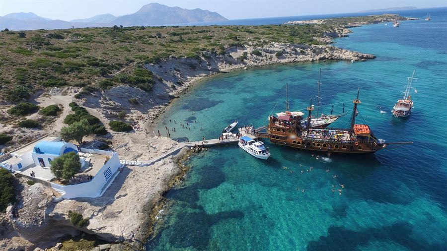
For tourism, a boat tour means a short outing in a fairly small boat. The home island of a Kos boat trip belongs to the Dodecanese. This is a group of Greek islands in the south-east Aegean. Kos is the third largest of them. Rhodes and Karpathos are bigger.
The island covers an area of 290.3 square kilometres. Its coastline runs for 112 kilometres, stretching from west to east. That long shore gives a Kos boat trip plenty of coast to follow. From the deck, passengers watch the shape of the land as the boat moves along its edge.
A cape is a headland pushing out into the sea. The south coast of Kos is steep. Hills run west from Cape Foca towards Pyli. The rocky slopes on this southern side are steep as well. On the north side, gentler slopes fall away to pine forest and farmland.
The 2021 census counted 37,089 people living on Kos. This gives the island the second largest population in the Dodecanese, after Rhodes. The town of Kos is the main town on the island. Local government for the island’s municipality is based there too.
- Skandari: This cape stands in the north-east of Kos and points out into the sea.
- Lakter: This cape stands in the south of Kos, along the island’s southern shore.
- Drekanon: This cape stands in the west of Kos, on the island’s western coast.
Kos Town and its port sit at the island’s eastern tip. For anyone planning a Kos boat trip, this eastern end is a useful point to get bearings. From there, the rest of the island stretches away to the west.
Which harbours serve a Kos boat trip?
A Kos boat trip can start at harbours like Mandraki, Kos Marina, Kamari Bay and Mastichari. Each harbour has its own setting. The main harbour of the island is called Mandraki. It sits in the heart of Kos Town.
The harbour at Mandraki also links Kos with Piraeus. Catamarans link Kos with nearby islands such as Rhodes, Symi, Leros, Kalymnos, Patmos and Leipsoi. A catamaran has two hulls set side by side. Mandraki is a busy place to start a Kos boat trip.
Kos Marina is a second starting point. A marina is a yacht harbour. This one sits a mile to the south-east of the old Kos Town harbour. It has 265 berths, and a berth is a place where a boat ties up. It takes yachts from 8 to 80 metres long.
Kamari Bay has a deep-water harbour at its western end. Steep cliffs rise above it on Mount Zini. Mount Zini is a volcanic dome, which means a hill built up by thick lava. A Kos boat trip from Kamari starts below those cliffs. A steep road climbs from the harbour to Kefalos village.
Mastichari has a port where boats leave regularly for the island of Kalymnos. This port makes Mastichari a natural start for a Kos boat trip to Kalymnos. Its story is short. People have lived in Mastichari only since 1933. That was the year an earthquake hit a nearby village.
- Fishing boats: Fishing boats based in the Kamari harbour sell what they catch to restaurants nearby.
- Coast road: From Kamari Bay, a road follows the coast on to Kos Town, about 40 kilometres away.
- Marina opening: Kos Marina officially opened its gates in 2001, on the fifteenth day of the fifth month.
The 2017 earthquake showed the value of more than one harbour. Cracks opened in the main harbour floor, so officials moved ferries to Kefalos. A Kos boat trip today can start from a wide choice of harbours.
What does Pserimos add to a Kos boat trip?
A Kos boat trip that calls at Pserimos adds an inhabited island to a day at sea. Pserimos lies in the waters between Kalymnos and Kos. The island covers 11 square kilometres of land, and people make their homes there.
Cruise boats in the area include Pserimos as a stop on their routes. From Tigaki on Kos, Pserimos and the islet of Plati lie about 3.5 kilometres north. Both rise from the sea in the same direction. For a Kos boat trip, that keeps the crossing modest in length.
Pserimos village, also called Avlaki, sits behind a gently sloping beach of fine sand. Swimmers near this shore can see Byzantine marble fragments gleaming beneath the water. Byzantine means the pieces date from the eastern Roman empire of the Middle Ages. The old stone turns a simple swim into a glimpse of history.
Back on land, the 19th-century church of the Panagia stands at the east end of the bay. It sits just 30 metres back from the shore. Inside stands a carved wooden throne with an unusual swan’s-neck design. A Kos boat trip that pauses here offers carved woodwork as well as sand and sea.
In 1888 the epigraphist W.R. Paton recorded an inscription bearing the island’s name. An epigraphist is an expert who reads old inscriptions. The text dated from the 3rd century AD and has since been lost. Even so, a Kos boat trip that stops here reaches an island named in writing long ago.
- Population: The 2021 Greek census counted just 84 people living on Pserimos.
- Early churches: Traces of four Early Christian churches, from the first centuries of Christianity, have been identified on the island.
- Courtyard stones: Ancient and Early Christian stonework in the church courtyard suggests the site is older than the present church.
Today, Pserimos lives chiefly from tourism. Greek and European visitors come for its remote setting and its beaches. For a Kos boat trip, that mix of quiet shores and old stone gives the day real depth.
What does Kalymnos add to a Kos boat trip?
A Kos boat trip to Kalymnos crosses to an island just 12 kilometres off. Mountains cover the bulk of Kalymnos, so its topography, meaning the shape of the land, is complicated. Not every route stops there, but those that do offer a change of scene.
Kalymnos measures 21 kilometres in length and 13 kilometres at its widest point. In 2021 the island had 17,752 people. That placed it third in population among the Dodecanese islands, behind only Kos and Rhodes. A Kos boat trip here therefore reaches a lived-in island, not an empty rock.
Seen from a Kos boat trip, Kalymnos shows a rocky landscape. Its imposing slopes are fragrant with thyme, sage and oregano. Among the fertile valleys, Vathy stands out, with turquoise fjords and calm citrus orchards. A fjord is a long, narrow inlet of the sea between steep slopes.
Pothia lies at the southern end of Kalymnos, beside a bay. It serves as the island’s chief port. The town also holds the main public services. Very close to Pothia lies Chora, also known as Chorio. Chora served as the old capital of the island.
History fans on a Kos boat trip find two castles here. The Castle of Chora, or Great Castle, crowns a steep mountain north-east of Chora at about 255 metres. Chrysocheria Castle stands between Chora and Pothia. The Knights of Saint John, a crusader order that ruled these islands, built it in the mid-15th century.
- Climbing: Kalymnos has more than 4,600 rock climbing routes set in its limestone.
- Neighbours: The island of Leros lies less than 2 kilometres away from Kalymnos.
- Area: In total, the land of Kalymnos covers 109 square kilometres.
The climate of Kalymnos allows climbing all through the year, not only in summer. Climbers can therefore plan a visit in any season. A Kos boat trip that includes Kalymnos adds land, history and outdoor sport to time spent at sea.
How does sponge diving shape a Kos boat trip?
A Kos boat trip on certain routes crosses to Kalymnos, the island billed as the “Sponge-divers’ island.” The sponge story explains both its harbour and its museums. That history turns a simple day at sea into a lesson in island life.
Long before a Kos boat trip carried visitors, Kalymnian sponge hunters worked as freedivers. A freediver is a diver with no air tank. Each carried a skandalopetra, a rounded stone roped to the boat, to sink fast. Down on the seabed, each diver freed a sponge and dropped it into a net bag.
Kalymnian crews ranged far beyond their home island. Their sponge grounds ran from nearby Pserimos all the way to North Africa. Kalymnos led the Aegean as its chief sponge-producing centre. Passengers on a Kos boat trip cross waters that once fed this trade.
Sponge diving carried grave danger. Decompression sickness is an illness in which gas bubbles form inside the body. Bubbles in the knees or elbows bend divers over in pain, giving the name “the bends.” In 1868, thirty divers worked at Kalymnos. Two of them died, and two more were left paralysed.
The sponges these divers collected are animals, not plants. They belong to a group called Porifera and are invertebrates, meaning animals with no backbone. The bath sponge, Spongia officinalis, grows across the Mediterranean. It lives as deep as 100 metres. A Kos boat trip sails over part of that Mediterranean range.
- Overfishing: By the mid-20th century, heavy harvesting had pushed sponges and the trade close to extinction.
- Sickness: In the mid-1980s, a disease hit the eastern Mediterranean, destroying sponges and damaging the sponge-fishing industry.
- Dance: The Kalymnos folk dance Mihanikos shows the crippling effects of decompression sickness on sponge divers.
Passengers who know this history see Kalymnos with new eyes. Each sponge stands for hard, risky work far below the waves. A Kos boat trip toward the island becomes a chance to honour those divers. Their courage still deserves respect.
What does Telendos add to a Kos boat trip?
A Kos boat trip that reaches Telendos shows travellers a small, steep islet just off Kalymnos. On boat days from Kos, visitors see an island that was once joined to Kalymnos. A major earthquake in 554 split the two apart.
That quake is known as the 554 Anatolia earthquake. It struck the south-west coasts of Asia Minor on 15 August 554. Asia Minor is the land across the sea to the east. Today a channel of water about 800 metres wide lies between Telendos and Kalymnos.
From the deck of a Kos boat trip, Telendos looks like one steep, flat-topped mountain. Its sides drop straight into the sea. A plateau called Rachi dominates the island. A plateau is flat high ground, and Rachi rises to a height of 460 metres.
A Kos boat trip to Telendos leaves car traffic behind, since the island has no cars. Its population stood at 66 people in 2021. The only village, also named Telendos, sits right across from Myrties on Kalymnos. Small sea-taxi boats link the two shores. A sea taxi is a small boat for hire.
Telendos holds traces of a long past. Late Roman remains lie mainly on the east coast, close to the village. They include old baths and an olive press. An olive press is a heavy tool that squeezes oil out of olives. A Kos boat trip that stops on Telendos puts these ruins within reach.
- Hiking: Telendos has no road network, which makes the island a good fit for hiking.
- Climbing: Climbers have had new sport-climbing routes opened up on Telendos since 2007.
- Size: The whole island covers an area of 4.648 square kilometres.
The islet is also home to Agios Konstantinos castle. Its building is thought to date from the later 7th century. It was a defence against Arab raids. A Kos boat trip with a Telendos stop mixes sea with history.
What does Kos Town show from a Kos boat trip?
A Kos boat trip leaving Kos harbour passes the Castle of Neratzia, which stands at the harbour mouth. The town’s waterfront spreads out behind the stone walls of the castle. Both sights share one wide view from the deck.
From the deck of a Kos boat trip, the castle’s setting is easy to read. It sits on a promontory, a point of high land jutting into the sea. In ancient times, this spot was an island. The Knights Hospitaller, a crusader order of knights, built the fortress.
Seen from a Kos boat trip, the walls tell a building story. Work on the castle began in 1436 and ended in 1514. Stones from the ruined ancient city went back into its walls. Columns, inscriptions, bases and epistyles sit inside the walls. An epistyle is the stone beam laid across the tops of columns.
A wide moat runs between the castle’s two baileys. A bailey is a walled courtyard of a castle. A ramp resting on arches crosses the moat. Across the water at Halicarnassus stood St Peter’s castle. Together, the knights’ towers kept watch over the sea route to the Holy Land.
The town also keeps a mark of the Ottoman era. The Loggia Mosque of Gazi Hasan Pasha was completed around 1777 or 1786. A minaret is a mosque’s tall tower. A tall, pencil-thin minaret rises from the north-west corner of the mosque. From a Kos boat trip, passengers can look for this slim tower.
- Dodecanese: The castle is a fine example of knightly fortress building in the Dodecanese islands.
- Phoinikon Street: Its name comes from the old palm trees, phoinikes in Greek, lining both sides.
- Italian rule: Kos gained the Town Hall, the Administration Building and the Archaeological Museum in this period.
Ancient Kos also left its mark close to the water. The northern side of the ancient market met the city wall. That stretch of wall ran toward the harbour entrance. A Kos boat trip leaving the harbour passes this same spot.
How does Hippocrates link to a Kos boat trip?
A Kos boat trip starts on the island of Hippocrates, the ancient physician, or doctor. Kos is thought to be his birthplace. His famous plane tree stands on land near the harbour town. So does the Asklepieion, a healing sanctuary of the god Asclepius.
Hippocrates is traditionally called the “Father of Medicine” for his lasting work in the field. His training is thought to have taken place at the Asklepieion of Kos. His teacher there was the physician Herodicus of Selymbria. Travellers who join a Kos boat trip set out from the island tied to this medical past.
Unlike the site at Epidaurus, the Kos Asklepieion developed scientific medicine. The school that Hippocrates founded on the island helped this growth. For visitors, that fact turns a Kos boat trip into more than a pleasure cruise. Its harbour sits on an island with deep medical roots.
Legend says Hippocrates taught his pupils the art of medicine beneath the Tree of Hippocrates. The tree is an oriental plane with a crown of about 12 metres. That crown is said to be Europe’s largest. Passengers back from a Kos boat trip can see its branches and picture those old lessons.
The Asklepieion stands on the slopes of a low wooded hill. It looks out to sea and to Asia Minor. Asia Minor is the name for the land across the water to the east. Its dates run from the 4th century BC into the 4th century AD.
- Oath: Hippocrates is credited with the Hippocratic Oath, a text still in use today.
- Tree age: The present tree is about 500 years old and possibly descends from the original tree.
- Layout: Planned as a single complex, the sanctuary gradually spread across three terraces.
The German archaeologist R. Herzog uncovered the sanctuary between 1901 and 1905. He acted on a tip from Iakovos Zarraftis, a historian from Kos. Today a Kos boat trip pairs well with a visit to these ruins.
Which southern beaches can a Kos boat trip visit?
A Kos boat trip from the south of the island reaches Kefalos Bay on the south-west coast. Two names stand out here: Kastri islet and Paradise Beach. Each boat sets its own route, so stops change from trip to trip.
The old village of Kefalos stands on a cliff top. It overlooks Kamari Bay, which also goes by the name Kefalos Bay. Kefalos has two parts. Kamari lies on the coast, and the traditional village sits on top of the hill. Both parts face the water that a Kos boat trip sails.
Out in the bay, a small church of Agios Nikolaos stands on Kastri, a small volcanic island. A Kos boat trip that visits Kastri brings passengers close to it. The white and blue chapel honours Agios Nikolaos, protector of sailors. Kos also counts him as its patron saint, the saint believed to protect the island.
Paradise Beach sits right in the middle of Kefalos Bay, about 35 km from Kos Town. An odd sight waits in the water. Bubbles rise from the seabed, caused by the remains of an old volcano below. When a Kos boat trip stops at this beach, swimmers see this for themselves.
The shore of Kamari bay also holds early church history. In 1932, the Italian archaeologist Luciano Laurenzi found two early Christian basilicas by the sea there. A basilica is a large early church. The well-preserved basilicas of Agios Stefanos date back to 469 and 554 AD.
- Camel Beach: This beach lies just before Kefalos Bay, 40 km from Kos Town.
- Kamari, Kampos and Onia: These resorts follow the bay for about 2 km below old Kefalos.
- Kardamena: Kardamena has crops and trees on one side and 6 km of sandy coastline on the other.
Visitors at Agios Stefanos walk among foundations, arches, columns and mosaic floors. Parts of baptisteries and altars survive. A baptistery is the part of a church used for baptism. The ruins give a Kos boat trip a link to the past.
What sea life lives along a Kos boat trip?
A Kos boat trip passes close to Natura site GR4210008. Natura 2000 is an EU network of protected areas. This Kos site covers about 101 km², including Cape Louros and a coastal sea zone. Both land and water fall inside it.
Posidonia, a seagrass, is a flowering plant forming underwater meadows. Inside the Kos Natura site, Posidonia beds cover about 501 hectares. A hectare is a unit for measuring land area, and here it measures the seafloor.
The bottlenose dolphin, Tursiops truncatus, appears on the species list for the Kos Natura site. Observers from the Archipelagos Institute of Marine Conservation work in the north-eastern Mediterranean. They recorded common, bottlenose, striped and Risso’s dolphins, plus sperm whales. A Kos boat trip offers no promise of meeting any of them.
The green turtle, Chelonia mydas, is on the reptile list of the Kos Natura site. Its records also note one subadult leatherback turtle, Dermochelys coriacea. Subadult means the animal was not yet fully grown. Both are wild animals, so a Kos boat trip treats any turtle sighting as luck.
The sea life here faces real threats. Posidonia grows only about 6 cm a year. When a meadow is destroyed, it takes centuries to return. Grouper and seabream in Greek Aegean waters face threats from overfishing and damaged habitats. These problems affect the same waters a Kos boat trip crosses.
- Noble pen shell: At Kos, Pinna nobilis is protected under Greek law and EU Annex IV.
- Open-sea fish: The wider sea between Kos and Tilos is very important for tuna and swordfish fishing.
- Marine research: The Archipelagos Institute of Marine Conservation is a Greek non-profit protecting sea life.
Remote coasts and plentiful sea caves make the eastern Aegean a key remaining home for the monk seal. Respect for wild animals matters at sea. A Kos boat trip that keeps its distance and its noise low helps protect this fragile sea.
Which season suits a Kos boat trip?
A Kos boat trip fits best in the warm seasons, summer and early autumn. At the Kos station, July averages a 30.4 °C daily high and only 2.2 mm of rain. For October, the Kos station lists a 23.0 °C average daily high.
Spring offers a cooler kind of Kos boat trip. At the Kos station, April highs average 18.8 °C. That air feels fresh on deck, and a sea breeze adds a chill. A warm layer makes sense for the ride back to port.
Kos has a mild winter and a dry summer. Strong winds are a regular feature of its weather. The Kos station records an average yearly rainfall of 602.3 mm. For a day on the water, the wind deserves as much attention as the sun. Rough water makes a ride bumpy.
Summer brings the etesian winds to the Aegean. The name traces back to the Greek word etos, or year, for their yearly pattern. In Greek, they are called meltemi, the strong, dry summer wind of the Aegean. They start around the middle of the fifth month. A Kos boat trip in summer can meet them.
Early autumn wins praise from the official Kos tourism site. It calls this season a fine time to explore, with mild autumn temperatures. For a Kos boat trip, that means mild days without the full force of midsummer heat. Long hours on deck feel easier in this softer weather.
- Weather check: Greece’s Health Ministry tells boaters to learn about the weather before setting out.
- Rough seas: The Greek Health Ministry advises against swimming when the sea is wavy or rough.
- Life jacket: The ministry also advises always wearing a personal flotation device, a life jacket, on the water.
During a heatwave, lukewarm showers by day are the advice of Greek Civil Protection. It also suggests wet washcloths on the head and neck. On a Kos boat trip, water, a hat and sun cream protect passengers from the heat.
What history does a Kos boat trip sail past?
A Kos boat trip sails past an island with a long and layered story. One early chapter came in the 11th century BC, when the Dorians, an ancient Greek people, invaded Kos. They founded a colony there with settlers from Epidaurus.
Early Kos belonged to the Doric Hexapolis, a league of six cities. Its other five members were Lindos, Kamiros, Ialysos, Knidos and Halicarnassus. Each name marks a place once bound to Kos. Passengers on a Kos boat trip can picture those old ties as the coastline slides past.
The capital left Astypalaea, near modern Kefalos, in 366 BC. The new capital was the freshly built town of Cos. Another chapter came decades later. Kos was the birthplace of Ptolemy II in 309/308 BC. His father was invading the Aegean at the time of his birth.
Kos later came under the Knights Hospitaller of Rhodes, a crusader order of knights. Under them, the island was called Lango, thought to be because of its length. During the Ottoman conquest of Rhodes in 1522, Kos was handed to the Ottomans by agreement. A Kos boat trip passes shores held by both powers.
The Kingdom of Italy occupied Kos on the 20th day of the fifth month of 1912. In 1933, an earthquake demolished 90 percent of homes in the historic centre of Kos town. Both events belong to the modern story that a Kos boat trip sails past.
- New town plan: Architect Rodolfo Petracco drew a new plan, and the old quarters became an archaeological park.
- Battle of Kos: This clash, part of the Dodecanese Campaign, saw German forces beat British forces for the island.
- Massacre of Kos: After the battle, 100 Italian officers who refused to join the Germans were executed.
German troops held Kos until 1945. That year, the United Kingdom took the island on as a protectorate. A protectorate is a land run for a time by a stronger state. A Kos boat trip passes a coast linked to each of these eras.
What does the north coast show on a Kos boat trip?
A Kos boat trip along the north coast shows long sandy beaches at Tigaki, Marmari and Mastichari. Behind those beaches sits a salt lake wetland, an area of land covered by shallow water. Boats on the north side bring both into view.
Tigaki is a seaside village with palm trees and long, wide beaches. The sand along its shore is fine and golden. In total, Tigaki beach extends for around 10 km. That length gives passengers on a Kos boat trip a long sweep of sand to watch.
Marmari is a seaside resort on the northern coast, 15 km west of Kos town. Wooden boardwalks lead through soft dunes to the sandy beach. Dunes are low hills of sand piled up by the wind. Tamarisk trees also grow along the way, and tamarisk is a salt-loving shrub.
Alykes, the salt lake of Tigaki, lies between Tigaki and Marmari. It is protected as a Natura 2000 site, within an EU network of such areas. Until 1989, it served as a sea salt production site. That past explains its abandoned buildings. A Kos boat trip passes the shore in front of it.
Pelicans and herons live around the salt lake. Water turtles and water snakes share the same home. During the autumn and spring migrations, pink flamingos and ruddy shelducks visit Alykes. A migration is a seasonal journey between regions. These seasons suit bird fans on a Kos boat trip.
- Mastichari: Fine sand covers the shoreline here, possibly mixed with gravel or shells.
- Sunset photos: The heart-shaped salt lake is a popular spot for photos, especially as the sun sets.
- Summer: The lake stays dry in the summer months, as rain is scarce and temperatures are high.
Away from the north coast, the Psalidi wetland sits roughly 4 km from Kos town to the south-east. Its size changes, covering between 85 and 100 hectares. Travellers who enjoy the salt lake view from a Kos boat trip can add Psalidi on land.
What questions come up about a Kos boat trip?
A Kos boat trip explores a Greek island that faces the coast of Turkey. The island airport stands close to Antimachia village. A hot spring warms the sea at Therma beach in the south-east. Mount Dikaios rises above the island.
How close does Turkey lie to a Kos boat trip?
Kos sits right across from the coast of Turkey, in the heart of the Aegean. Boats cross a 20-kilometre stretch of the Aegean Sea to reach the island from Bodrum in Turkey. The island also sits where the Gulf of Gökova opens to the sea. A gulf is a large bay.
Where is the airport for a Kos boat trip?
The island’s airport is Kos International Airport. Its other name is Ippokratis, a name taken from Hippocrates. The airport stands near the village of Antimachia. It lies 24 km from Kos Town, just off the provincial road that runs from Kos to Kefalos.
Which hot springs sit near a Kos boat trip?
Therma beach, also called Embros Thermae, lies below a cliff at the south-easternmost point of Kos. A spring meets the Aegean on the shore, forming a sea pool where hot water mixes with seawater. The spring water runs between 42 and 50 °C, warmer closer to the source.
Which mountain rises above a Kos boat trip?
Lagoudi village sits on the slope of Mount Dikaios, also called Oromedon, in north-eastern Kos. Asfendiou stands on the mountain too, 14 km from Kos Town to the south-west, among olives, cypresses, pines and springs. On a clear day, the summit shows Gyali, Nisyros, Pserimos, Kardamena and the heart-shaped Tigaki salt lake.